Zugspitze via Höllental route
This page chronicles my hike to the top of Zugspitze – Germany’s highest mountain – over the Höllental route. While this ascent does not require technical climbing it is still quite tough, since it involves a height difference of almost 2200m (7200ft), a small glacier crossing and a via ferrata for the last 400m height meters.
An early start
Since I did not want to be surprised by thunderstorms or bad weather rolling in throughout the afternoon, I had decided on an early start. I got up at 4:30am and drove the short distance from Garmisch-Partenkirchen, where I’d spent the night at Gästehaus Angela. I parked the car at the Höllental parking, 0.5km away from the trailhead. After some minor delays I started hiking at 5:15am.
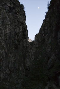
Höllental gorge
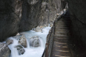
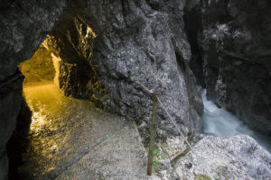
The first part of the hike was over a nice footpath to the base of the Höllental Klamm. I arrived at the bottom of this narrow gorge at around 6am. Since the entrance booth was not manned yet, entrance was free. The sky was starting to get brighter, but not all of that light filtered down because of the surrounding steep walls. Still, a headlight wouldn’t have been all that necessary by this point anymore. The trail was blasted in the stone, and crossed the river in a few spots. There were also some tunnels. All throughout the gorge, it was drizzling down, and I got lightly soaked a few times by water coming down from the walls above.
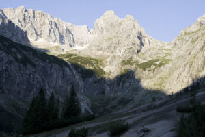
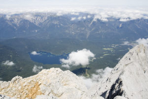
After slightly over half an hour – I could have hiked faster if I hadn’t stopped for pictures so often – I was at the top end of the gorge, and the valley widened. In the distance, I could for the first time see my destination for the day; but by the time the view was unobstructed the deep red morning glow was already gone.

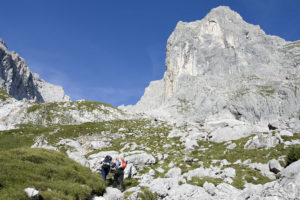
Höllental valley
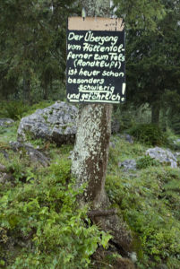
At 7:10am, I passed Höllentalangerhütte. A lot of people ascend to here on the previous night, shaving off two hours and about 600m of elevation from the day’s climb. I continued, noting the sign posted on a tree just next to the hut that said the Randkluft – the crevasse that forms between the ice of the Höllentalferner glacier and the rock above – was very difficult and dangerous.

“Leiter”
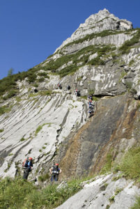
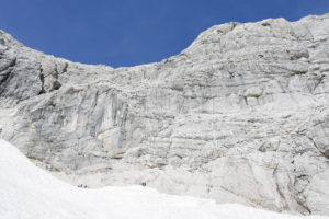
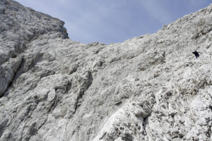
I followed the trail, which was still pretty wide and easy going. The surrounding mountains were now getting full sunlight, even if the valley was still in shadow. I passed a first large group of hikers, and arrived at the first cable-secured passage shortly before 8am. I put on my climbing harness and helmet. Soon after, the “Leiter”, an iron staircase over a steep rock wall was the first real obstacle of the day, but one easily mastered. The following horizontal traverse over the rock face gave an indication of what was still ahead: there’s no way I could have crossed this part of the trail if I hadn’t had the iron cables to hold on to, and the knowledge that the harness would not permit me to fall very far in case I slipped.
“Brett”
About a quarter of an hour later, I arrived at the “Brett”, another smooth rock face that needs to be crossed with the help of an iron cable and iron bolds that serve as foot rests. I was surprised how easily I mastered this passage, but once more it was probably the climbing harness that gave a lot of confidence.
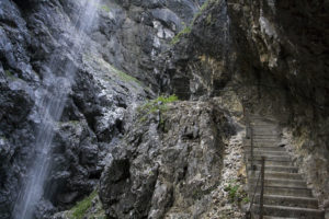
After a bit of scrambling over rock, not very difficult but not secured by cables, the trail leveled out again and I took off the helmet and started using the hiking poles once more. From here, the trail would climb over meadows first, and over scree slopes afterwards.
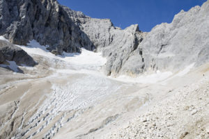
Höllentalferner (glacier)

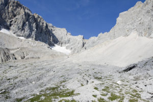
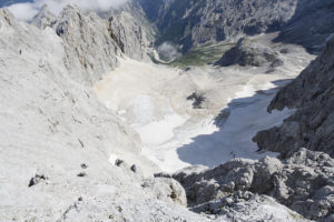
I arrived at the base of the Höllentalferner at around 9:45am. I stopped for a quick bite, and to put on my crampons. The route I’d need to follow up the glacier was easy to follow – I’d seen people on it during my ascent, and there were enough foot steps visible to remove any doubt. I started at around 10am, climbing to the left side of the crevasses, and the crossing over to the right side of the glacier where the via ferrata would start. I’m not sure if it was the length of the hike as such, or the particular strain imposed by walking with crampons, but by the time I had climbed half of the glacier my quadriceps started locking up. I managed to loosen them sufficiently to keep on climbing however, and was soon at the top of the glacier.
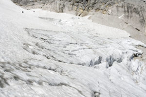
The Randkluft
At around 10:30am, I watched some hikers cross the Randkluft and ascend the first few meters of the rock-route. This was supposed to be the difficult and dangerous part, and I couldn’t help but agree. A look down the Randkluft was intimidating, because a fall down would not just have been a couple of meters. Thankfully, there was still a small snow bridge linking the glacier and the rocks on the other side, or otherwise the hike would have ended for me at this point.
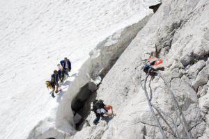
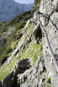
As is, the only question was, would I get rid of my crampons before crossing the snow bridge, or afterwards? While the preceding hikers had done the former, I decided that I’d feel more secure if I did the latter, especially since there was one iron bolt in the rock where I could secure myself with the climbing harness while getting out of the crampons. I thus got rid of them, fastening them to my backpack with a cable binder, and shortened my hiking poles. And then there was another difficult part, because the next five meters or so I’d need to climb over rock without any means of securing myself with the climbing harness. A slip here would not just have sent me down those five meters, but also into the Randkluft between the rock and a glacier. The next few meters, a horizontal traverse was even more exposed, with only two iron bolts as support for the feet but no cable to secure myself onto. Only afterwards, the first cable appeared (not very assuring-looking, still), and only after rounding a bend there was a small plateau with a decent cable and a means to calm my nerves that had flared up a bit over this part – definitely the most dangerous climbing I’ve done in my life so far. I was glad that there a total of five people closely behind, because even though they couldn’t have prevented a fall their presence still reassured me.
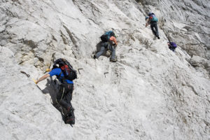
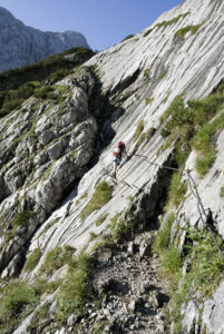
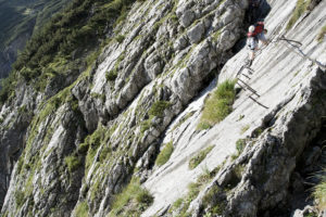
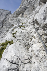
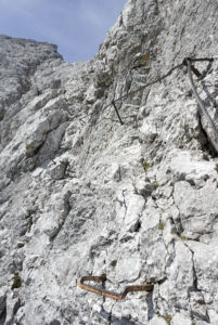
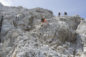
Via Ferrata (Klettersteig)
From here, the climb over the Via Ferrata would still lead me over a lot of exposed terrain, but all of it would be secured by steel cables, iron bolts, or both. I started this part at around 11am. The following two hours would be spent climbing up, stopping every so often to take pictures of the route below and ahead. The difficulty level wasn’t very high, I think, even though I probably used the cable as a support a lot more than most climbing purists would. (The question being, should the cable be used only as a last resort, using natural rock holds whenever possible; or as a means to drag oneself up the mountain? Since this was my first such climb, and I started to be exhausted, I played it safe and used whatever means that were easiest.)
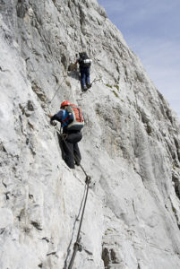
Constantly unclipping and clipping myself into the cables was tiresome, but really added a sense of security. Some other hikers I met on the way up didn’t clip themselves in as religiously as I did. Overall, my ascent speed was probably decent for the first half of the climb, but then I started feeling really exhausted and my pace slackened.
I rested at a small spot that was wide enough to sit a few hikers, and talked with two other hikers for a while. The total duration of the stop was probably around half an hour. The more experienced of the two hikers said it would probably be around 45 minutes to the top, but I failed to meet that prediction. My progress had become definitely slower as exhaustion set in with full force, and as such it took me almost exactly one hour to make it to the top.
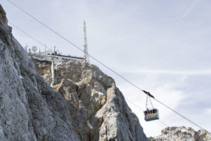

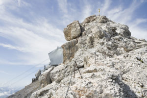
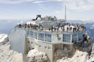
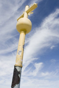
At the top
Since there’s cable cars going almost right to the top of the mountain, the peak was busy; and swarming with all kinds of people who couldn’t have made it to the top without some kind of mechanical assistance. I only stopped briefly, snapped some pictures of the mountain cross and the various buildings; and then bought a ticket for the voyage down. A headache – probably stemming both from my lack of altitude adjustment and the merciless beating of the sun – made me think that I should descend to a lower elevation sooner rather than later.
Since the cable car to Eibsee couldn’t cope with the volume of people wanting to go down, I took the cable to the ski area on the other side of the mountain; and then from there the cog rail to Eibsee. At 25.50eur, this was quite costly, but still better than hiking all the way down and possibly killing my knees in the process. Shortly before reaching the Hammersbach rail station I still had to switch trains, and then hike about 0.5km back to the car, where I arrived at 3:45pm.
Overall, the hike up had taken me eight and a half hours.
Hi,
I read your blog about climbing zugzpitz via hollental route. It was quite informative and helpful.
So me and few of my friends are planning to hike zugzpitz via the same route.I had few questions?
1) can it be hiked in a day
2) is there any place where we could rent the gears and if yes, which all gears needed to be rented?
3) is it dangerous to hike there without a professional guide?
4) if someone does it in 2 days, is there any option to stay overnight?
Appreciate your help !
Cheers,
Roshni
1) If you’re in decent shape, it can definitely be hiked/climbed in a day. I did. But bear in mind that from the valley floor to the top it is 2200m of elevation gain; which is considerable.
2) I’m sure there’s shops in Garmisch or elsewhere that will rent you gear (crampons, etc.). However, if you’re not sure about what gear to rent and/or have never used a ferrata set or crampons, I’d suggest using a guide.
3) It’s been ten years since I did this, so I’m not the one to ask about current conditions. But this is alpine territory, and a lack of experience and/or a mistake could get you killed. If you have any doubt, use a guide.
4) There’s the Höllentalangerhütte that is located about 2 hours into the climb. There’s no option to overnight elsewhere on the route.
Here’s the current conditions: https://www.alpenverein-muenchen-oberland.de/hoellentalangerhuette/tourenverhaeltnisse. You may not understand the language, but you can look at the pictures – they should give a good indication of the most difficult part (where you cross from the glacier onto rock).
Hope this is helpful. I certainly don’t want to come across as overly negative, but by default I’d rather err on the cautious side. Not knowing you or your experience (or that of your friends), I’d definitely advise you to either look at getting a guide or doing one of the easier routes first.