Race Report: Ring of Steall Skyrace 2017 (29km / 2500Hm)
For some people, going up a mountain, traversing a narrow ridge and then descending over 1000m of elevation again is a day’s work. At Ring of Steall skyrace, I’d do that twice in less than 7 hours; going up and down over 2500m of elevation in the process, more than I’ve ever done in a single push.
Half a day after a strenuous climb up and down a mountain (see my Mamores VK race report), I was lining up at the same starting line again, this time to cover a longer distance than I’d ever ran, with more elevation than I’d ever climbed. What could possibly go wrong?
My preparation had certainly gone quite well – I’d covered a lot of elevation while vacationing in the Alps two weeks prior to this race; and I was surprisingly refreshed after a good night’s sleep.
I arrived bright and early to a fairly busy parking at Kinlochleven, passing the remaining time to a fellow athlete who I’d initially met on Instagram.
At 10am sharp, we were sent off. The first kilometer was on pavement, and people were really pushing the pace. Since I did not want to go out too hard, I settled in a reasonable pace, which of course meant that come the first gently climbing single trail, I was stuck for better or worse in a conga line that dictated the pace.
After 2.5km and about 250m of elevation gained, we’d joined the “Old Military Road”, a short level stretch on gravel. We’d follow this jeep road for about half a kilometer before reaching the first checkpoint of the race at 23:29 elapsed.
It was drizzling at this point, but not in such a manner as to require rain gear. Instead, some people got out their hiking poles. The trails were still a little too congested for that, and poles made it both harder to pass and get passed, but with all the elevation changes ahead I figured I could use all the help I could; so I extended mine as well.
The next few kilometers would be an unrelenting climb to the Mamores ridge. While the going was never overly steep or technical, it still required a lot of concentration to get a good foothold on the slippery stones, and to step around the biggest mud holes. The trail was exclusively of the “single” variety, but apart from a few rare overtaking maneuvers the people around me had settled into a nice, steady pace that I was happy to follow.
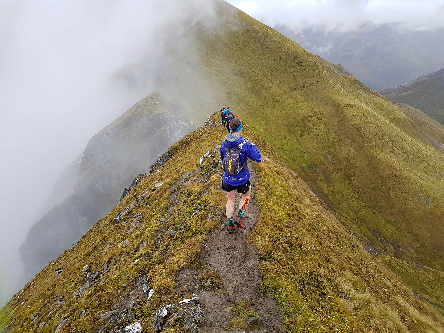
At 1:11:21 elapsed I reached the Mamores ridge checkpoint. I had covered almost 6km and around 900m of elevation gain. We were now on a fairly broad ridge. A few people took the opportunity to don rain jackets, more to protect against the cold than ward off rain which had thankfully stopped by this point. I was still managing fine without a windproof layer, especially since before too long we were once again climbing. We’d soon reach our first munro of the day, Sgorr an lubhair; which also marked the first time of the day that we reached 1000m of elevation.
I had my chip scanned at the Sgorr an lubhair checkpoint, at 1:20:39 elapsed. The tally was now about 6.5km of distance and 1000m of elevation gained. With the first highpoint of the day out of the way, next came a short rocky descent of only around 50m of elevation.
After this quick and easy descent behind us, we were starting our climb towards the next peak of the day. But to get there, we first had to cover a bit more distance on increasingly rocky terrain which was a bit slippery due to the rain, and then traverse the famous Devil’s Ridge, a knife-edge trail with scary-looking fall-offs on each side. Fortunately, cell phone and Gopro footage of this ridge make it look more dangerous than it really is (as long as you’re careful), so I made decent progress.
After the Devil’s ridge came a few short technical passages that required a bit of scrambling. Here, a bit of congestion formed as people were careful on the slippery rock.
I arrived at the Sgurr a’ Mhaim checkpoint after 1:46:22. By now, I had covered around 8km. As nice as it was to have reached the highest peak of the entire race at 1099m of elevation, I still had most of the 2500m of descent ahead of me, and would still need to climb over half of the remaining elevation.
Pretty much the moment we passed the checkpoint, a bunch of runners came flying past. They’d mastered the first big technical difficulty of the day and were now happy to let gravity to its work and assist them on their way down towards the next checkpoint. I was taking it a little more cautiously, not so much because the footing was terrible but rather because I didn’t want to subject my knees to the added strain of a full-speed hill descent.
Initially, the descent was on gravel, which also meant that inevitably a few small stones made their way into my shoes. Eventually, we reached a greener environment once again, with the trail going down in innumerable switchbacks. Here, it was quite difficult to overtake people; especially since what looked like a shortcut usually tended to be more technical and/or slippier. I was stuck behind a slower descender once or twice, and mostly took it instride. Only one time, I got a little cocky and tried to pass, and was immediately rewarded with a small slide that had me land on my rear. No damage was done, but I realized that I needed to be more careful. As such, I concentrated on descending and did not take a single picture on these switchbacks.
Before too long, we were back on grassy slopes. With the amount of people that had gone down before, that also meant there was quite a bit of slippery mud.
After all was said and done, I’d descended close to 1050m and reached the Glen Nevis Support post checkpoint after 2:29:21 and about 12.5km covered. This meant that I was ahead of the 4h cut-off time by a very comfortable margin.
This was also the location of the single aid station on the trail. I refilled my water flasks (all three of them for a total of 1.5L), but decided to not waste any time beyond that at the busy aid station.
Instead, I sat down next to it for some emergency maintenance on my shoes: on the long descent, the insoles of my Salomon Speedcross 4 had moved all the way forward into the toe box, where they had bunched up. This had not been comfortable, but since there was no dry spot to sit down anywhere, it had had to wait until here.
Next up was a fairly level stretch, first paralleling the Glen Nevis road and river, and then actually continuing on said road for a bit. This roughly 2.5km stretch of comparatively easy terrain allowed me to catch a breath and to make an attempt at catching up on my calorie intake. Easier said than done, however, and one of the peanut-based energy bar that I brought was difficult to swallow while running; so I drank quite a bit of water to wash it down.
The Glen Nevis road dead-ends at around the 14km point. The signs going forward are maybe a little dramatic, but it’s probably a good way to scare away tourists with less secure footing.
I continued running as best as I could, switching to a fast hike whenever teh ground became too soggy or the trail technicalities demanded for it. I’d long given up trying to keep my feet dry, but it was still a challenge to find the driest possible route.
Part of the time, we were on the Steall Falls path, part f the time we seemed to be contouring it in boggy marsh. Before too long, the imposing An Steall Waterfall came into view.
Near the waterfall, we had to cross the Water of Nevis, a fairly wide but not very deep river. Those who had managed to keep their shoes dry up to here were certain to get them now. I was also happy that I was not wearing any kind of long trousers, because the water got almost up to my knees at some point. Crossing a river invariably means stepping on unstable roundish stones, so it was a bit of a struggle to get across without a misstep – I certainly would not have liked to submerge myself into the cold water.
Just beyond the river crossing was the An Steall Waterfall checkpoint. I had reached it after 3:19:34. By now, I’d covered 16km of distance.
The checkpoint also marked the start of the second serious climb of the day. But first, a bit more foot-deep bog to make sure that the shoes that had been cleaned by the river fording were once again clad in brown mud…
Up until now, I had been feeling mostly fine. But pretty much as soon as I started the climb up, I began to realize the (comparative) enormity of what still lay ahead. True, I had covered over half of the race distance by now and also slightly less than half the elevation gain and loss, but all of that had been on fresh legs. By now, my legs were certainly not fresh anymore.
I wasn’t the first to have these kinds of thoughts. I came upon a runner (coming back down the mountain) who announced that he wasn’t feeling well and was returning to the lower checkpoint to DNF.
The climb took me a long time. I was still moving steadily, but by now I had given up all pretense of still being able to run uphill. Thankfully, neither were the people around me. We all suffered at about the same pace.
Ascending from the waterfall to the next munro, a distance of around 3km with 740m of elevation gain took me over an hour. I reached An Gearanach checkpoint (982m) after 4:23:15 elapsed. The top runners had already arrived at the finish line by now.
Beyond the peak, another ridge scramble awaited. This one was probably the most technical of the bunch.
Next up was another short descent, and then the next ascend loomed. I’d come close to my limit at this point, and was getting frustrated by a bit of a gear meltdown. I thought I had been smart by pinning my bib to my backpack (instead of my shorts or pants), but since I’d stashed my third water bottle in the rear pocket of my backpack, I was now unable to get to it. Removing the backpack meant removing the pins holding the bib; which wasn’t easy with cold hands and the impatience of being in a race. After a lot of frustrating fumbing around, I eventually asked a passing runner to grab the bottle for me.
The entire ordeal had cost me quite a few positions and made me quite grumpy, and it didn’t help that I was looking at another climb. On paper, it was only 100m of elevation, but in reality it felt like a mountain on its own.
I had reached Stob Coire a’ Chairn checkpoint after 5:02:32. Distance wise, it was only about 1.2km from the previous peak, but the frustrating water flask fiasco led to me taking a whopping 39 minutes.
Fortunately, up ahead was a fairly gentle descent during which I could recover a little.I even manage to run a few steps to break up the tedium of all those power-hiking climbs.
Before too long, I was facing the final climb of the day, up Am Bodach. Once again, 200m of elevation gain would feel like a piece of cake on most days, but here with the accumulated fatigue of the day, it felt much steeper than that.
And with that climb out of the day, I finally reached the fifth and last munro of the day. I passed Am Bodach checkpoint after 5:36:19. I’d done 22km up to here, which meant I still had a 7km long descent to look forward to. At least from now on, I would be on the Mamores ridge again, which meant I could more or less have visual contact with the finish line.
I consumed a gel on the initial descent on the Mamores ridge. Oddly enough, I seemed to get an energy kick out of it; or maybe it was just the effect of passing one or two runners who looked like they were much worse for the wear. From what I understood, they had been out of water for quite a bit, which reassured me in my decision to bring along 1.5L on this stretch (which I’d almost fully consumed by this point).
I reached Mamores Ridge checkpoint after 5:50:53. With roughly 22.6km done, I was now back on the same route that we took on the way up.
The descent towards Kinlochleven is a bit of a blur. A muddy, slippery blur, but still. I encountered a few runners who were cutting corners and not respecting the flagging, but instead moving straight over pristine green instead of the energy-sapping mud traps that the trail had become by this point with well over 1000 people traveling over it.
I took that as a bit of a challenge, to make sure that those people cutting corners would at least arrive behind me. So I made good use of my sticks to propel myself over the worst mud holes, and generally pushed myself harder than I had over the previous couple of hours.
By the time I reached the jeep road, I had created a bit of a gap. Channeling some inner rage against a fairly minor transgression against race rules into running energy had worked. I checked in at West Highland Way, the final checkpoint for the day, after 6:26:54. 26km done. The finish line was within reach.
But of course the easier trail would mean that other runners would be able to run faster, as well. So I kept pushing myself to run as fast as I could. With the exception of one competitor who flew past, I managed to keep everyone else safely behind me.
Before too long, I was back on the road, which meant I had less than one kilometer to go. I looked behind me, didn’t see any immediate threat, and felt relief that I wouldn’t need to sprint on the final meters.
One last turn, across the finish line and I went straight to the ground, plopping down on the rough gravel and consuming a few cups of water that were brought over by volunteers.
I had finished my longest and steepest race.
My final time was 6:47:22, and I finished in 255th position. In total, 440 people would cross the finish line that day.