In a vertical kilometer race, or kilomètre vertical (KMV) as it’s sometimes referred to in France, the goal is to ascend 1000m of elevation by running (or walking) the shortest possible route on roads or trails. For the Mont-Blanc Vertical Kilometer, the route starts at the Place de l’église just outside the city center at 1000m of elevation and ends at Plan Praz, a gondola lift station at 2000m elevation in the shadow of the Brévent mountain.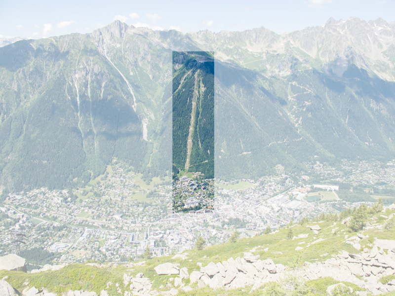
 On June 26th 2015, I was about to enter this race for the first time. I was a relative newcomer to the mountain running scene, having just run two other mountain climbs in Germany and Austria in the preceding months. Both had been learning experiences, and enabled me to see where my limits were.
Two days before, I had done a reconnaissance hike of the entire race course. (This is where I took almost all of the pictures used in this race report.) Getting a good look at the course and trail conditions in advance didn’t just mentally prepare me for what was ahead, but also allowed me to fine-tune my clothing and hydration choices, especially since the weather was forecast to be the same.
Rather than following the traditional form of a group start (which would get very crowded on the narrow trails higher up the mountain), the Mont-Blanc Vertical Kilometer is run as a time trial; with athletes starting every thirty seconds over the course of several hours. The way this is handled is that the slowest athletes start at 16:00, and depending on your projected finish time you gave them when signing up you’re then put into a time slot (17:30 in my case) around which you can show up at the starting line. You don’t necessarily need to be on time ‘like a Swiss clock‘ – there’s no exact sequence that is strictly enforced, since you’re scanned individually as you set off and that’s when your personal timing starts.

 In my case, I set off at 17:19, a few spots behind Charley and Sophie, whose blogs I had found while researching the race and who I had been following on social media. As such, I knew that Sophie was aiming for a finish under 1 hour; which was also my goal. With no other points of reference, these guys (who didn’t know me) would in a way be my implicit pacers, and I knew that if I lost ground to them my pacing wasn’t working.
The city center was quite crowded, and as such everyone sets off to constant applause and encouragements. It’s a little intimidating, and you tend to maybe go off a little faster than you’d planned. I ran past the church, through a traffic circle (traffic police was stopping the cars whenever a runner approached), and then up Rue de la Mollard, a paved road that has an approximate 14% grade.

While I’d done a lot of training for this race, a badly inflamed achilles tendon had put a damper on the amount of cardio I’d been able to do in the months leading up to the race. As such, I had to be very mindful of my heart rate, and knew that I would speed hike a majority of the course rather than being able to run most of it. I was still dismayed to find that I’d reached my limit in the middle of Rue de la Mollard already.
After about 0.5km on the road I then contoured around the Brévent cable car station, and after just a short stretch of wide gravel I reached the start of the switchbacks. Since I was one of the first people to switch from running to power hiking, I’d already lost a position or two.
After about 700m of distance we reached the start of the switchbacks we’d be on for the next half hour or so. It’s all single trail, which makes it quite a lot harder to pass people (or be passed). Soon, we reached 100m of elevation. Only 900 left!
 On the switchbacks, I was able to cover ground comparatively well. My speed hiking pace enabled me to keep up with most of the people around me, regardless of whether they were running or hiking, and I even managed to pass a few. Most people were courteous in letting faster athletes pass, and likewise I stopped a few times in the curves of the switchbacks to let someone faster pass me. One person did not move over to let me pass as expected, and a sudden evasive step into grass that I chose to make almost caused me to fall and my heart rate spiked. No other damage done, so I soldiered on. My heart rate at this point was around 177, peaking to 180; which is also very close to my maximum heart rate.
Not much changes as I passed the 200m, 300m and 400m markers. While there were still a few position changes, things had settled down somewhat. Mostly, I tried to inch closer to the person in front of you, while in turn peeking back each time I changed direction on the switchbacks to see if I was opening up a gap towards the people following.
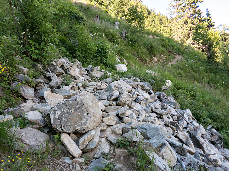
 Somewhere around the 500m marker, we reached the sign announcing that the trail was no longer maintained beyond this point. Mostly, this meant that there were occasional small boulder fields to cross, and that the footing was more treacherous in some spots with either loose stones or loose dirt.


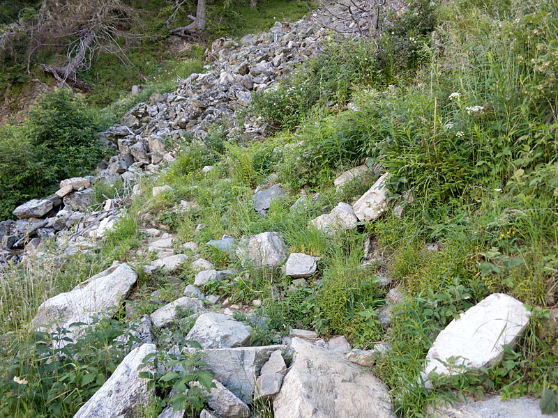


 Somewhere after the 600m marker, we left the switchbacks behind. Whereas the trail had been going up below the cable car line, we were now starting on a line that veered off to the right and contoured around the mountain slope.

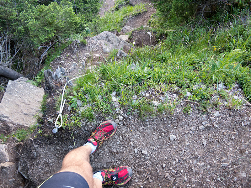
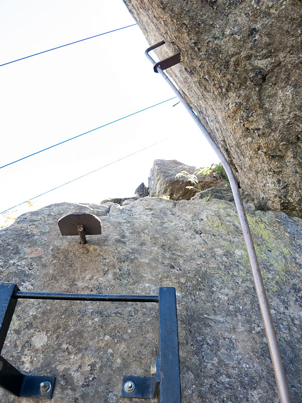
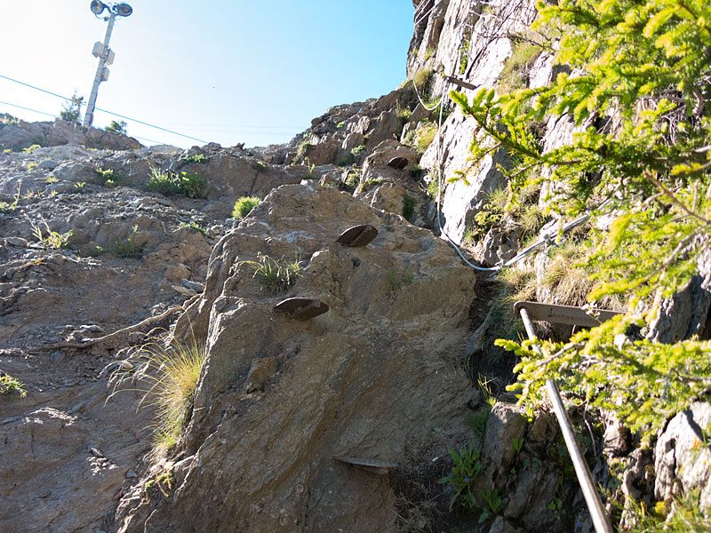
 And then the 700m marker came, and it was time to get the hands dirty. In some spots, the trail seemed to go up almost vertically between jagged boulders. There was a cable to hold on to, and I used whatever strength I could muster in my upper body to assist my legs by pulling myself up on the cable.


 There were a few spots where a slip or fall would have been painful, but it was always manageable. While the field had thinned considerably by this point, I caught up with a few more people on this stretch. I suppose this is where weaknesses in your strength or endurance will catch up with you.
After the 800m marker, one can finally see the cable car station. Unfortunately, there’s still quite a bit of ground to cover on difficult terrain. This is the rockiest part of the course; and an iron rope was no longer sufficient. The boulders one needs to climb up are quite big. As such, there was an assortment of ladders or iron foot holds, with a guard rail to hold on to. This part of the race culminates in a spot where runners climb up with a sheer rock face on their right and a slippery gravel slope to their left. Here, race photographers set up shop because you can get a nice shot of runners with Chamonix in the valley below as a backdrop.


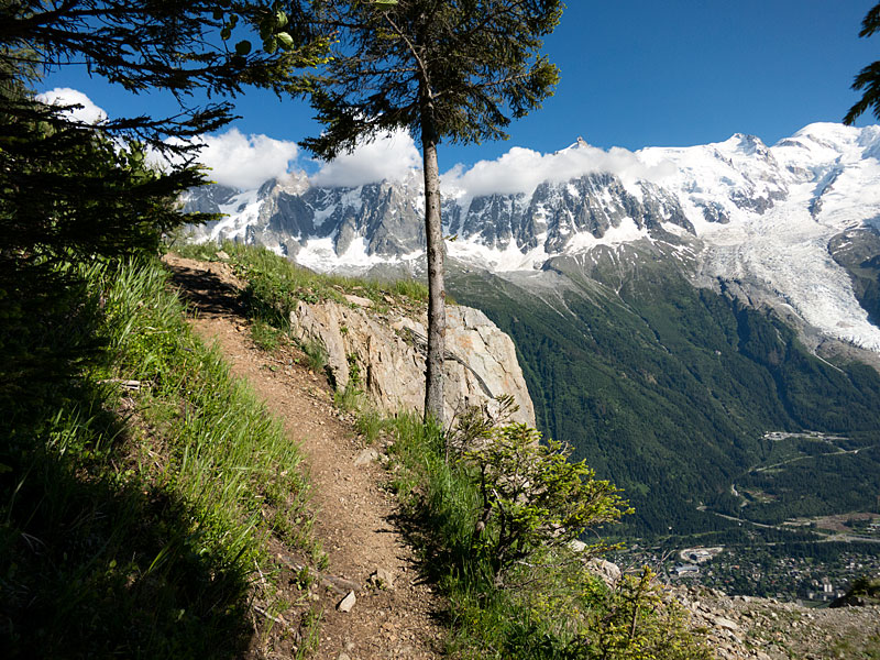
 Beyond the photographers, the trail mellows out a little. With most of the climb facing into the Brévent massif with my back to Mont-Blanc, I was happy to find that for a short while the trail actually opened up with splendid vistas of mountain peaks and glaciers across the valley.
 I passed the 900m elevation sign and another official photographer, and then the cable car station was almost within reach. The climb is less dramatic here, but of course with the accumulated fatigue I still didn’t manage much of a run.
 After the relative quiet of the climb, the cable car station was much busier with spectators. The path leads over some wooden planks and then up some iron stairs. This of course marks the end of the single trail, and the remaining distance is on a wide dirt road. On its own, the remaining elevation change would not be drastic, but after climbing for close to an hour near my maximum heart rate, it was really hard to convince my legs, lungs and heart to allow me to run over the finish line. I managed, barely.


 And just like that, the race was over. Almost straight away, I could see my official finish time on a timing screen, and had the confirmation that I’d stayed under one hour. I loitered around the finish area for a bit, taking photos and sending a text message to the wife saying that I’d survived.
After just a few short minutes, I was feeling quite well again (maybe I had energy reserves I could have tapped into during the race?). I set off to hike/run up to the Brévent, but then after the first bend reconsidered because after all it wasn’t just a jog up the hill but could easily have added an hour or two and maybe caused me to miss the last gondola down if something unexpected happened. Instead, I returned to the finish line to see the fastest athletes arriving. It was a bit disappointing to realize that there wasn’t more of a crowd – their finish times certainly warranted more attention.
After the final athlete arrived, everyone seemed to be in a mad rush to get down the mountain. I decided that with nothing else to do that evening, that I’d attend the victory ceremony (which was held on the main square near the starting line) as well. There was a lottery for all participants, and as luck would have I won a fairly nice supply of Isostar running nutrition (gels, powder, etc.). Afterwards, I set off towards the gym where the pasta dinner was held. This was a no-brainer since (a) it was on the way to the hotel, (b) it was included in the price and (c) I hadn’t eaten dinner yet.
The pasta was good, but of course it was no fun eating in solitude. I guess when elite runners always talk about the camaraderie among athletes, they may be right about it from their point of view; but as a random guy among other random people, a lot of them in established groups, it was hard to make contact with anyone. I didn’t particularly mind though, and instead soon headed out; walked the remainder of the way to my hotel and settled in for a good night’s rest.
Here’s my Strava activity for the race.
Gear that I used:
- Brooks Cascadia 8 shoes (These have been my go-to shoes for most of my trail running in 2014 and 2015, so it was logical to wear something that I knew would work. )
- Ronhill Men’s Trail Cargo Contour Shorts (The differentiating factor between these Ronhill’s and comparable running tights is that they offer plenty of pockets so I could safely stash my cell phone, some paper tissues, my ID and hotel keys in separate locations. Otherwise, I’d always be afraid to, for example, lose one thing if I grabbed another.)
- Under Armour Sonic Compression Men’s T-Shirt (Not much to say. A lot of similar running shirts would have worked just as well).
- Ultimate Performance Handheld Bottle with hand strap (It is debatable whether much water is needed on a <1 hour run. However, I emptied the 0.6 litre bottle on the way up; and when the sketchier parts came I was able to use the strap to fix the bottle on my upper arm and thus have both hands free for climbing/scrambling.)
2 Comments Add yours